Monday, April 30, 2012

The Accretionary Wedge 45 - Geological Pilgrimage

The Accretionary Wedge is back for its 45th edition this month and it is a great topic: 


Geological Pilgrimage – the sacred geological place that you must visit at least 
once in your lifetime. 


This topic is further defined as a single place, which is “geologically” unique,  relatively remote, and requires some difficulty to get to.


I have thought quite a bit about where I would like to make my pilgrimage too...at first it was tough to narrow it down as great places that I have never been kept jumping into my head: the Grand Canyon, the barren tundra of Antarctica and/or Ellesmere Island, the Everglades (just got back), the diamond fields of South Africa, Mt. St. Helens, Etna, Stromboli, the island of Elba, the mud volcanoes of Kazakhstan, the gem mines of Burma, the zeolite pits in Pune, India, the ancient silver mine in Laurium, Greece...aaahhhhh....the list is almost never-ending actually. However, one place rose to the top of my list: Iceland!   


Long ago a pilgrimage was usually a journey that someone undertook to visit a place at the heart of their religious faith. e.g. Rome or Mecca. The pilgrimages of yore however, were often epic journeys that took months or years and involved great personal risk to the traveler as they ventured through wild and untamed country. Happily in today's world even the most remote places on the globe are accessible by air so in terms of remoteness Iceland is 3,833 km away, so um, I guess that is pretty remote....and in terms of its difficulty to get too...well I have to go all the way to Toronto from Ottawa to fly there and that is a big pain. 


The whole point of the pilgrimage though is not necessarily how far you have to go, but the experience of the journey and the place you are venturing to. For my geological pilgrimage I wanted a place that would leave me in awe at the inner workings of the Earth, and that while not only being a spectacular place to visit, would also give me a sense of being somewhere that has a geologic story to tell that integrates many periods of Earth history. The most incredible geologic places that I have stood have all given me the same feeling. It is a sort of heightened awareness of the interconnectedness of the Earth processes that wrought such fantastic things, the time that it took to create them, whether it be millions of years or mere minutes, and finally the Earth is something so much more complex and wonderful than I could ever fully comprehend. A good place for a geologic pilgrimage has to deliver that sort of mind-blowing feeling. 


I think that Iceland is just such a place, and here is why: 


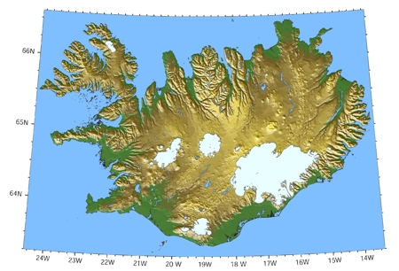
Relief map of Iceland
Formation
Iceland is located in the North Atlantic and, despite its chilly sounding name, is not covered in ice, although it does have glaciers. Indeed, the origins of Iceland are anything but cool (haha) as it was born out of rifting and volcanism. Approximately 130 million years ago a large magma plume welled up from the mantle under the supercontinent Pangaea. The plume, which had a diameter of 2000 km eventually led to rifting between the North American and Eurasian plate and large scale volcanism about 60-55 million years ago. As the rifting continued the two plates began to separate further and form what is now the North Atlantic ocean. As the plates continued to separate the plume remained fixed as the plates passed over it. This led to a trail of plume material that can be seen in Greenland. To get a better idea of what I am describing imagine you are holding a sheet of paper and pulling it down over a ball. At the beginning the paper simply bulges upward, however if you pull longer and harder eventually it tears. This is analogous to how the crust behaves when a mantle plume is rising under it and how the plume leads to rifting and eventually the breakup of a supercontinent. The mantle plume still exists under Iceland and is the reason for the many earthquakes, volcanic eruptions and continuing geothermal activity that occurs there today.
3D image of the mantle plume under Iceland
Over time rifting between the North American plate and the Eurasian plate continued eventually leading to the formation of the Atlantic Ocean. At the centre of the Atlantic ocean is the Mid-Atlantic Ridge which is a place where the two plates are separating due to magma upwelling along the length of the ridge. Imagine a long mountain range of volcanoes along the bottom of the ocean. 


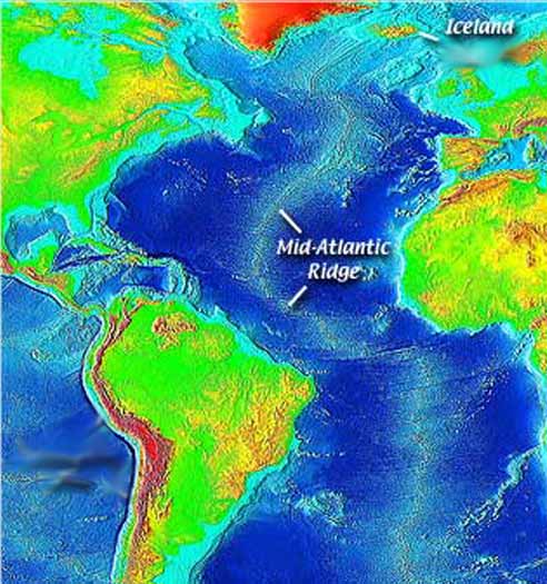
The Mid Atlantic Ridge

The island of Iceland sits in the middle of the diverging plates and is actually part of both the North American plate and the Eurasian plate. Iceland has a two large rifts running down its middle and it is actually possible to go stand in the Mid-Atlantic Ridge where it surfaces in Iceland. I would like to go stand there; right in the place where two massive tectonic plates are slowly but inexorably splitting apart changing the face of this planet as they have done for billions of years. 


The outcrop of the Mid Atlantic Ridge (note: this photo came from the Smithsonian's list of 43 places to see before you die, so I guess I'm in good company)

The other major reason that I would like to go to Iceland is to watch a geyser erupt. Iceland is the original home of the geyser. Indeed, the word geyser is Icelandic for the verb to gush, and that is exactly what geysers do. Geysers spew jets of superheated water high into the air on an intermittent basis. They are the perfect combination of structural geology, geothermal heating and groundwater and I am dying to see one in action!
02226-2609_IMG.JPG
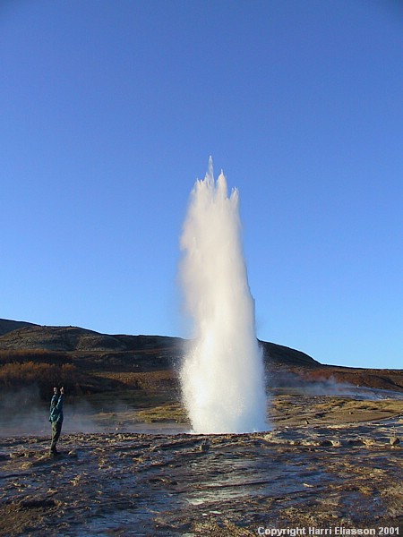
Strokkur Geyser, Iceland
Geysers exist only under perfect circumstances when there is ample heat, a ready supply of groundwater and a plumbing system of interconnected fractures and cavities. The mechanism that leads to a geyser erupting is complex. It begins with groundwater infiltrating the “plumbing system” of the geyser and beginning to fill it. The geothermally heated rocks heat the water to its boiling point. Meanwhile the reservoir is continually filling with cooler groundwater. The hot water at the bottom of the reservoir forms bubbles which rise heating the rest of the water to boiling temperatures. However, the very hot water at the bottom does not actually boil because of the pressure exerted upon it by the overlying cooler water until all of the water in the plumbing system has reached its boiling point. Once all of the water starts to boil the bubbles of steam begin to multiply rapidly until there are too many to escape causing a drop in pressure within the plumbing system. This sudden drop in pressure causes all of the water to boil and explode out of the reservoir causing the huge fountain of boiling water that constitutes the eruption of a geyser. This process then repeats itself as long as there is an ample supply of heat, and the groundwater recharges the reservoir. 


I have other reasons for going to Iceland as well. Some of these include seeing glaciers, seeing an active volcano, going in a volcano (I only learned that this was possible today), and seeing some of the incredible cultural history the island has to offer. Hopefully I can check Iceland off my list of places to see soon!! 


Matt


References:


Allen, R. M., Nolet, G., Morgan, W. J., Julian, B. R., Pritchard, M., Ragnarsson, S., & Stefa, R. (2002). 
Plume driven plumbing and crustal formation in Iceland, 107.
http://eps.berkeley.edu/~rallen/pub/2001icecrust/Allen2002IcelandCrustJGR.pdf

http://www.smithsonianmag.com/specialsections/lifelists/Icelands-Volcanoes.html

http://academic.emporia.edu/aberjame/student/brown3/iceland.htm

Saturday, April 21, 2012

10 Reasons Geologist's are Weird

As the title says geologists are an odd breed, full of personality quirks that separate them from say...everyone else. So at the encouragement of my girlfriend, who is not a geologist and is therefore perfectly positioned to observe the quirkiness of me and my geo friends we are making a list of geologist quirks.

1. Many geologists think about rocks, minerals, fossils and their PhD thesis (me) while laying in bed at night. This is pretty strange behaviour since the rest of the population thinks about normal but way less interesting thins such as sports, politics, you name it, only geologists think about rocks.

2. Geologists suck at navigating in cities, but can always find their way in the bush. For example, two of our friends were coming over and while they have lived in Ottawa for a combined 7 years they ended up completely lost and on the wrong street. When we asked how the hell did you get lost they said "we knew it was in the 300's and we just though we'd feel it out when we got close". Indeed they did get close just on the wrong street, which in the city is terrible navigating. However, you put these two in the bush and they can navigate their way to the only outcrop for miles through dense undergrowth and led only by their "feelings".

3. Geologists tell really bad puns and make a LOT of dirty geologist jokes. Honestly, the list of dirty geologist jokes has to be miles long by now. All you have to do is find any pub on any given night in any given city and you will likely see a few wearing a stupid shirt that says something like: "Geologists make the bed rock", "Are you (Mg,Fe)7Si8O22(OH)2", and a personal favourite of mine: "My cephalopod is long". I take that they mean an orthoconic cephalopod that is.


Orthocone cephalopod
4. Uncyclopedia says that geologists may be the Earth's only alcohol based life form and far be it from me to disagree. In fact, I agree wholeheartedly. Many of the grad students in my department engage in an activity called "lunch beers". This entails leaving the office at around 11am, going to the nearest bar and ordering about a pitcher per person and sitting their drinking until about 2 or 3pm when they come back to the office if they ever come back at all...

5. Geologists dress weird. See my previous post on geologist stereotypes for a full description. Another example would be any number of eminent geologists who could be mistaken for homeless men due to their long brown/black/white hair and beards, torn field clothes that they wear to work every day and, of course, hiking boots.

6. Geologists actually want to get coal in their stocking for Christmas or any other rock. When I was a tiny geology enthusiast and rockhounder I would always ask my parents for new samples to add to my collection at Christmas. Another good example of this is that the child geologist will save all his or her allowance money to spend it on rocks and minerals when they go to a show. Normal kids buy CD's, clothes, toys, etc. Indeed, this is why I have horrible knowledge of pop music from my own generation, but a massive mineral and fossil collection. 

7. Speaking of rock shows...when geologists say "rock show" they don't mean music. This actually happened to me. The annual Ottawa gem and mineral show was going on one weekend and I asked my new housemate, Chris, if he wanted to go to a rock show on the weekend with me. His response was "Hell yes". A few days later on the Saturday of the show Chris asked me if "shouldn't we go get some booze so we can pre-drink before the show". I gave him a confused look and then explained to him the true meaning of rock shows. We then went to the show where I got some great samples for our shared living room. 

8. Geologists are annoying to drive behind. As a geologist I know that when I travel on highways in the Canadian Shield I am annoying to drive behind because of my erratic speed. Whenever I pass a roadcut I am compelled to have a closer look and that means slowing down and possibly even pulling over if it looks really promising. However, this must be really irritating to people driving behind me since roads in the Canadian Shield are almost all outcrop and my pattern of slowing down then speeding up as soon as I pass is must drive them crazy. So here is a sorry to them from me and all other geologists like me.

9. Geologists think that a good rock hammer can be used in any situation. For example, a rock hammer makes a great nut opener/crusher. I have used mine many times to crush nuts and seeds for recipes since I don't own a food processor. All you have to do wrap the hammer in saran wrap and go to town. It works like a charm and is great fun. It also helps keep my aim sharp in the winter when there are no rocks outside to practice on. 

10. The final oddity in my list, and believe me there are a lot more than 10, is that geologists love to be in harsh, remote places. To many in the general population camping involves driving to your site, making a campfire in the little metal thingy and cooking dinner. This can be fun, especially with lots of beer on hand, however, geologists want more. To a geologist the more remote the better. If my field site is fly-in only, hundreds of kilometers from the nearest outpost of civilization I am happy, as long as there is still beer that is. The other odd thing that goes along with this is that geologists are competitive with one another about how remote their field work is. It is not uncommon to hear lines at the bar that go as follows:

Geologist A: "Just got back from the field and boy was it ever a great trip! My beer ration was huge. We were working about 100km north of the Arctic Circle drilling ice cores. The camp was only accessible in the winter by snow mobile then we transferred to dog sled at Eagle Plains." 

Geologist B: "Wow! That sounds like a great trip! I just got back from my field season as well. My work was prospecting for new kimberlite pipes on Herman Melleville Island. We had to get helicoptered onto the island and then walk 300 km north. Hell, I must have been a good 1000km north of the Arctic Circle." 

Geologist A: "Oh yeah, well my cephalopod is longer."

I hope that you enjoyed my little top 10 list of geologist weirdness. If you have any other examples of geologist's being strange I would love to hear them so please comment!!

Matt
  

Friday, April 20, 2012

Happy 214th Birthday Sir William Logan

Today is the birthday of Sir William Logan, the father of Canadian geology and the founder of the Canadian Geological Survey.

Sir William Logan 1869

William Edmond Logan was born in Montreal, Quebec on April 20, 1798. He was educated in Edinburgh, Scotland and became interested in geology when he was operating a family owned coal mining and copper smelting business in Swansea, Wales. As he grew more interested in geology he produced a map of the coal seams in the district and the strata beneath them. His primary observation was that the strata underlying the coal always contained numerous fossils of plants and he concluded that the the coal was formed from these plants. This was a major step forward in the understanding of coal at the time, which was one of the most important commodities of the time.

Logan then returned to Canada and his experience and insight led to him becoming the first director of the newly formed Geological Survey of Canada (GSC) in 1842. He mapped large swathes of eastern Quebec, the Ottawa Valley and the north shore of Lakes Huron and Superior. He also established the Geological Survey of Canada Museum in Montreal in 1857.

Geological Map by Sir William Logan and James Hall 1869

Sir William Logan was knighted by Queen Victoria in 1855 and retired from the GSC in 1869 at the age of 71 and after the publication of his work the Geology of Canada. He passed away in Wales on June 22, 1875.

Page from the Geology of Canada

His imprint on the development of geology in Canada was and is still profound to this day. His pioneering efforts, painstaking observations of fossils and minerals and collecting paved the way for the next wave of geologists in Canada and the exploration of Canada's mineral wealth. He is honoured by having Mt. Logan, the highest peak in Canada named after him as well as the Logan Medal which is the highest honour in Canadian geology. Finally the mineral Weloganite, found in Montreal, is named for him.

Mount Logan, Yukon

Matt

References: 

A great source where you can see everything about William Logan, including his personal notebooks.

Wednesday, April 11, 2012

Some Facts about the Moon

Last week our department (Earth Sciences at the University of Ottawa) was lucky enough to have a guest speaker: Dr. Caroline-Emmanuel Morisett from the Canadian Space Agency.


The title of her talk was simply the Earth's Moon. Myself and many others in the department attended the talk and I have to say that I was living in ignorance about that great piece of cheese in the sky...actually, one of the things I learned is that the Moon is not made of cheese...so there you go.

Here is a list and some description of the all the things that I learned about the Moon from the talk. I hope you learn something too.

- The temperature of the Moon at the equator ranges from -170C to 130C due to the fact that the Moon has no atmosphere. (I can't type the degree sign in Blogger)

- The average density of the Moon's crust is 3 g/cm^3 as opposed to Earth which is 5.5 g/cm^3. The reason for this is that the Moon has much less iron in its crust than the Earth

- 380kg of Moon rock have been brought back to Earth.

- The mineralogical composition of the Moon is similar to Earth's mantle.

- Oxygen isotope ratios in lunar minerals are the same as they are on Earth.

- There are several hypotheses that exist for the creation of the Moon.
           - The first is the impact model which states that the Moon was created when a giant meteorite, about     the size of Mars collided with the Earth and broke a piece of it off which then became the Moon. This is the most widely accepted theory.
           - The second is the capture hypothesis which states the gravity of the Earth sucked the Moon into orbit around it. This theory is not generally accepted since the composistion of the Moon and the Earth are so similar which would not be the case unless the Moon came from the Earth.
           - The final theory, which is brand new, is called the fission hypothesis. It states that the the great amounts of heat generated by radioactive decay on the early Earth caused some melting. This then led to some of the molten Earth being spun off from the equator and then coalescing to form the Moon. This theory also proposes that the early Earth was spinning much faster in the past than today. From what I have heard the theory has met with mixed reviews, but I don't know the details very well.

- The Moon has quite varied topography.

Map of lunar topography. White and red are very high.
- The highlands of the Moon (red parts) are composed mostly of anorthosite, which is a type of intrusive igneous rock that is compose primarily of feldspar with some fraction of other magnesium, iron rich minerals such as olivine, ilmenite, magnetite and pyroxene.

- The lowlands of the moon, particularly in the bottoms of craters tend to be composed of the extrusive igneous rock basalt.

- There is water on the lunar surface in the form of ice that is buried beneath a very thin layer of "soil". Some minerals also contain up to 46 ppm water.

- One of the minerals which make up a small fraction of the basalt that is common on the lunar lowlands is ilmenite (FeTiO3), which is an iron titanium oxide.

Ilmenite crystal, Froland, Aust-Agder, Norway
- Ilmenite, which contains oxygen, can compose up to 20% of some lunar basalts. The oxygen found in ilmenite could be extracted and used to sustain life on the Moon should we establish a base there. It could also be used to make rocket fuel. 

- Originally the molten Moon formed a plagioclase feldspar crust due to magma differentiation. The moon was then heavily bombarded by meteorites that made it look like swiss cheese.

- Radioactive decay caused melting of the Moon's mantle and the filling of the craters by lava, which then cooled to form basalt.

OK, so those are the cool things about the Moon that I recently learned. I hope that by posting this a few of you learned something cool about the Moon as well. Feel free to comment below on which of my facts you thought was the most interesting or another crazy lunar fact that I didn't mention.

Matt

This is a pretty awesome photo of the Moon.

Tuesday, April 3, 2012

Perpetual Oceans Video

Here is another very cool example of dynamic geology art. This video, called Perpetual Ocean, was created by NASA and shows the movement of ocean currents over a period spanning from July 2005 to October 2007. The video is silent and simply shows the swirls and patterns of ocean currents around the globe. The video was created using a computer model called Estimating the Circulation and Climate of the Ocean, Phase II (ECCO2). The model incorporates ocean temperature and flow data to create a web of white and blue lines that reflects the velocity of ocean currents. According to NASA their goal was "to use ocean flow data to create a simple, visceral experience."  In my opinion they succeeded in a big way! This video is truly beautiful and is another great example of geology art in that it unifies impact and is beauty. Enjoy the video!

Matt