Wednesday, April 20, 2011

Spotlight on...wait for it....THE PLEISTOCENE

So much has happened over the course of geologic time that it seems only right to give each period its due and talk a little bit about the cool geologic and evolutionary events that occurred within it. The first one that I am going to look at is the Pleistocene, which is actually defined as an epoch, a subdivision of a period, and ran from 1.8 million years ago to 11,800 years ago.

The Cenozoic Era

While the Pleistocene represents a very, very small portion of geologic time, it was a time of great change that shaped the world of today. What is even more crazy is that I don't mean this in the overused, figurative way that we are all sick of hearing. I literally mean a few gigantic ice sheets actually scraped over the top of the northern hemisphere and changed its entire topography, covering up to 30% of the Earth in ice. Not everywhere was glaciated however, most of Asia, South America and Africa were not glaciated, but even these were heavily influenced during the Pleistocene. However, I am from Canada, and as you can see below most of Canada was run over by an ice sheet a few kilometers thick completely altering the landscape.


The causes of the Pleistocence glaciation are likely due to several factors working in concert to induce an ice age. One of these factors are Milankovitch cycles, named for Serbian geophysicist, Milutin Milankovic. Milakovitch cycles describe the periodic changes in the Earth's eccentricity (the shape of the Earth's orbit), which is a 100,000 year cycle, the obliquity or tilt of the Earth's axis which is a 41,000 year cycle and the Earth's precession or the wobble of the Earth as it spins around its axis (imagine how a spinning top can wobble) which occurs on 20,000 year cycle. Sometimes these factors align to bring the Earth further away from the sun, which causes the surface temperature of the Earth to drop.

Add caption

Changes in ocean currents are also very important factors in controlling global temperature. Ocean currents are essential for regulating global temperature by transferring warm water from the equator northward to the poles. Changes in the paths of ocean currents due to changes in the positions of the continents or ocean chemistry can also have the opposite effect. Once the pathway of an ocean current changes the warm temperatures that they bring will move with them.

Finally, another factor, one that has been discussed very, very extensively is atmospheric chemistry albeit with the emphasis on global warming rather than on global cooling. The general consensus is that carbon dioxide is to blame for all climate change and damn any other factor. The theory is that high CO2 leads to, or is a symptom of global warming and that low CO2 is a cause or a result of global cooling. Whichever, comes first the chicken or the egg, you cannot deny that CO2 and climate are related.

The ice sheet that covered Canada and much of North America was known as the Laurentide Ice sheet and existed for approximately 70,000 years and was up to 3km thick. In fact, the glacier was so thick and heavy it compressed the land beneath it, which is now only still rebounding back to its original position and will continue to do so for the next few thousand years.  There were several periods of advance and retreat during the Pleistocene leading to massive changes in the landscape and the formation of large glacial lakes, rivers, eskers, moraines and other glacial landforms. If you travel in Canada every landform you see, besides a special place called Beringia in the Yukon, has been glaciated and you are looking at a terrain that is only 10,000 years old. Some remnants of the Laurentide Ice sheet still exist today. The Barnes Ice Cap on Baffin Island is one key example and there are several exposures of Laurentide Ice in thaw slumps near Fort McPherson, Northwest Territories. The glacial period ended approximately 10,000 years ago for much the same reasons as it began. Due to a combination of Milakovitch cycles, ocean currents and atmospheric chemistry. One interesting theory that I heard recently is that mammoth farts caused a massive increase in the atmospheric methane concentration, which helped end the Pleistocene glaciation...all I can say is I am glad the planet has had some time to air out.

Buried ice from the Laurentide Ice Sheet. Once you wash it off it is very tasty (really!)

The glacial history of the Pleistocene is really cool (pun intended). But, there are other interesting aspects to the Pleistocene besides glaciers. Some of the Earth's most incredible animals lived during the Pleistocene. The Pleistocence was the time of megafauna. Megafauna is a blanket term that refers to many of the animals of the time, which, while very similar to those of today were just way bigger. For example, polar bears of today are very large at 680kg and 3m in length. However, the giant polar bears of the Pleistocene were about 1200kg or more and 3.7m in length. This scaling up of Pleistocene fauna can be seen in giant wolves, beavers, sloths, lions and some birds in North America and in other types of creatures on other continents such as kangaroos, emus and crocodiles in Australia. The reason for the extinction of the Pleistocene megafauna is still a subject of great debate. Some of the arguments are that climate change and the resulting habitat loss led to the extinctions and others believe that over-hunting by humans was a major factor.

(Karen Carr)
 Check out the comparison of a modern kangaroo leg bone to that of a short faced kangaroo from the Pleistocene:

(Matt Herod-2009)
So humans have been around much longer than 10,000 years. What were they doing when everything was covered in ice and the animals were way bigger? Well, there are many theories for the spread of mankind and the colonization of North America. One of the most popular is that a land bridge existed between Russian and Alaska which allowed prehistoric man to cross into North America. Coincidentally, this section of the Yukon and Alaska was the only place not to be covered by the Laurentide Ice sheet. This allowed for the first settlers to make their way south unimpeded by ice. There was also ample hunting of megafauna in the region. In fact, numerous artifacts have been found throughout Beringia that show the evolution of  hunting techniques and technology.

File:Beringia land bridge-noaagov.gif
Video showing the shrinking of the Bering Land Bridge

Alright, that is all for now. Thanks for reading.

Matt

Wednesday, April 13, 2011

About a glacier: The Franz Josef Glacier, New Zealand

Hi all,

Sorry for the recent hiatus in blogging. I have been in New Zealand for the last three weeks at a conference and then doing a bit of travelling around the south island. New Zealand is a beautiful country and, besides being scenic, is very interesting geologically. With this in mind, I decided to share one of the many highlights and do a little research about it.

Here it is:

The Franz Josef Glacier (March 30, 2011). There is a rock slide taking place out of view on the left that is making things dusty that day. (Photo: Matt Herod)

I spent a day on the glacier hiking around and ice climbing on the glacier. The guides, who were excellent, gave us lots of basic information about the glacier. Frankly, I was more focussed on climbing than on taking detailed field notes so now it is time to dig a little deeper.

The Franz Josef was named after Emperor Franz Josef I of Austria by explorer Julius von Haast  in 1865. However, in New Zealand every place also goes by its name in the Maori language, which for the Franz Josef glacier is Ka Roimata o Hinehukatere meaning "The tears of Hinehukatere". Maori legend for the formation of the glacier is that Hinehukatere loved to climb mountains and convinced her lover Wawe to accompany her. Unfortunately, Wawe, was swept away by an avalanche. Heart broken, Hinehukatere began to cry and her tears froze forming the glacier. 


The Franz Josef is a very active glacier. This means that even though it appears to be an unmoving and unchanging mass of ice at any given time, it really is continuously undergoing changes to its shape and movement. In fact, the Franz Josef is one of the fastest moving glaciers advancing or retreating at up to 1000m/year or 0.00011 km/hr, which is a blindingly fast pace for a glacier (Anderson, et. al., 2008). 


Over the last decade a number of studies have been done to understand the the response of the Franz Josef glacier to climate change. As one of the most studied glaciers in the Southern Hemisphere the Franz Josef serves an excellent indicator of how climate change will affect glaciers of similar size and dynamics. In order to gauge the response of the glacier to climate change a few key variables must be investigated: changes in ice thickness, ice flow velocity, and comparison of these factors with past data on the terminus position. 


Here is a picture of the current terminus. 


The terminus of the Franz Josef Glacier (March 30, 2011)
Over the last few hundred years the terminus position of the glacier has moved around four kilometers both forward and back due to climate changes. Here is a graph showing the behavior of the Franz Josef terminus over the last 100 years. 


(Hooker, et. al., 1999)
To summarize, this graph is showing that up until 1940 the terminus position was receding slightly, however, this drastically increased until around 1982 when it reached a minimum. Since then the terminus has advanced to its present day position. 


The causes for the change in terminus position are complex making it difficult to point a finger at any one factor, as is always the case with climate. However, there are several factors, working in concert, that are responsible for the retreat or advance of the glacier. Some of the factors proposed by B.L. Hooker, a researcher from the University of Otago, are that the retreat phase is caused by warmer than average summer temperatures, less precipitation, changes in local wind patterns, more La Nina events, and atmospheric pressure changes. The causes for the advance of the glacier are the opposite of the ones listed above. 


Over the last 100 years there is evidence for the occurrence of all of these factors making it impossible to find a "smoking gun" for glacial retreat or advance. The only real conclusion that can be made is that despite ongoing global warming throughout these times the cycle of advance and retreat is controlled by more than just changes in temperature and that despite warming temperatures glacial advance is possible when there are other factors at work. 


That is all for now. Thanks for reading.


M


References:


Anderson, B., Lawson, W., & Owens, I. (2008). Response of franz josef glacier ka roimata o hine hukatere to climate change. Global and Planetary Change, 63(1), 23-30.


Hooker, B. L., & Fitzharris, B. B. (1999). The correlation between climatic parameters and the retreat and advance of franz josef glacier, new zealand. Global and Planetary Change, 22(1-4), 39-48.


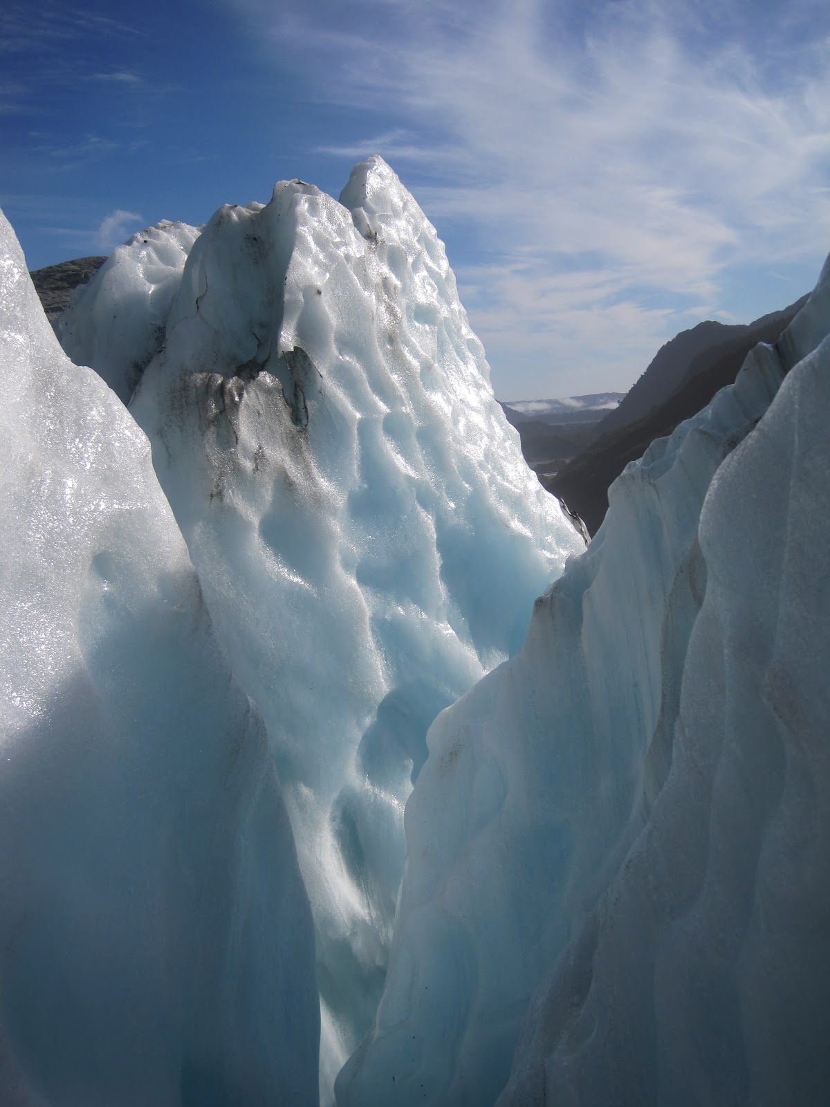
Here are some cool photos I took of the Franz Josef.


Monday, March 14, 2011

Geoscience Frontiers: The oldest water ever!!!

That's right! The oldest water ever found on Earth has been discovered and dated at 2 billion years. 
Up until now I have written about very well understood geologic concepts. I think it is now time to push the boundaries a little bit and attempt to review and simplify ongoing research. The article I have chosen is hot off the press and I only learned about its existence through seeing a breakdown of the article on CBC and then hearing about it on Quirks and Quarks.

The article is entitled: 
Neon identifies two billion year old fluid component in Kaapvaal Craton
Chemical GeologyIn Press, Corrected ProofAvailable online 6 February 2011
Johanna Lippmann-Pipke, Barbara Sherwood Lollar, Samuel Niedermann, Nicole A. Stroncik, Rudolf Naumann, Esta van Heerden, Tullis C. Onstott

Sounds pretty complicated eh? But it doesn't have to be...


First, lets describe the setting of this paper. The sample collection was performed at the bottom a large gold mine in the Witwatersrand Basin which is part of the Kaapvaal Craton located near Johannesburg, South Africa.


Cratons of Southern Africa


The Kaapvaal Craton was formed during the Archean period between about 3.07 and 2.71 billion years ago as a result of several large granite bodies emplacing themselves into the continental crust. The emplacement of the granite batholiths was then followed by several continental collisions by island arcs throughout the Archean. This led to mountain building and subsequent erosion of these mountains leading to the formation of thick sedimentary and volcanic sequences over the Kaapvaal Craton some of which now compose the Witwatersrand Basin. Many of these sedimentary were metamorphosed to a low degree over time giving rise to the hydrothermal gold deposits in the area. 


In this study, water samples were collected from nine gold mines in the Witwatersrand basin in order to try to establish the age and origins of waters deep beneath the surface of the Earth and look for evidence of life in this hitherto unexplored potential ecosystem. The water samples came from fractures in the rock deep underground, fluid inclusions within the rock itself and fluid inclusions from quartz veins. 


(J. Lippman-Pipke et al., 2011)


These waters were analysed for their neon isotope ratios (turns out it can be used for more than just colourful signs after all). Neon (Ne) is one of the noble gases and is very nonreactive under normal environmental conditions.  This inert nature of neon allows it to be used as a tracer. It can be used to trace fluids from their origins, fluid transport and the ages of the fluids that neon is dissolved in. I am calling the water in the fractures and fluid inclusions "fluids" because they are so saline that they don't fall under the same category as normal water. Neon has several natural isotopes that are produced in different ways and exist in constant ratios to one another. For example, the neon ratio of the atmosphere is different than that of the mantle as the neon in the atmosphere comes from different sources than neon in the mantle. Most of the ratios we find in water today are mixtures of many different neon sources making it difficult to distinguish one source. Much of the neon found in the subsurface comes from nucleogenic sources. What this means is that the neon we find in the subsurface is actually created there through the interaction of alpha radiation from uranium and thorium with oxygen and fluorine in the rocks. When the alpha radiation interacts with the the oxygen and fluorine it is changed into neon. This means that the amount of neon that is produced is proportional to the amount of uranium, thorium, oxygen and fluorine that is present. This process takes place in both the crust and the mantle, with each location having its own characteristic neon ratio, due to the differences in chemistry between the crust and the mantle. 


In this study the neon isotope ratios were analyzed in the fracture water to see if there was any contribution of neon from the mantle and to date the water.  The results of this paper show that there are some anomalous values for neon ratios present. Neon ratios traditionally plot along a straight line between the neon ratio found in air and that of crustal fluids and don't deviate from this line. This means that any neon ratio along this line is simply a mixture of these two end members. However, the neon ratios found in this study DO NOT fall on the neon mixing line and are unlike any neon ratios that have ever been reported! 


(J. Lippmann-Pipke et al., 2011)

These anomalous neon ratios are the highest ever recorded in groundwater or fluid inclusions. Now, given what we know about neon ratios this could be caused by any number of factors. For example, really high levels of uranium could produce a high neon ratio, or lots of oxygen and fluorine. However, this is not the case. To find the real answer for the anomalous values we have to examine the source of the water being analyzed.

The water that is being analyzed and contains the high neon ratios is not from a single source. It is, in fact, a combination of water from two isolated reservoirs. The reservoir that is the source of the high neon ratios is fluid inclusions. Fluid inclusions represent "time capsules" for geologists. They are like little bubbles of water that were trapped when the rock formed and have not been added to, subtracted from or changed in any way since the time of formation. This means that even if the water was trapped billions of years ago, as is the case in this setting, it has not changed since and represents the chemistry of water billions or millions of years ago.

The authors of this paper suggest that the water in the fluid inclusions contain a nucleogenic neon signature that is two billion years old and was produced by natural nuclear reactions and radioactive decay that took place in Earth's mantle!!! Pretty damn cool if you ask me.

So that is all for now. If you have any questions don't hesitate to ask. I'll do my best to answer. I leave for an international conference on Accelerator Mass Spectrometry in a few days so I'll post any cool things I see at the conference.

Matt


Tuesday, March 8, 2011

The Media Portrayal of Geologists

I have been wanting to write a somewhat humorous post for a while, so we will take a break from the science...for now.

As a geologist I find I am often stereotyped by people I meet and, by the media portrayal of my profession as a hard drinking, hiking boot wearing, bearded, bush man/woman who wears only plaid and carries a knife on my left hip and a hand lens on my right. Now, if you have met me, you know that most of this is actually true....but maybe me and others are all just conforming to the media portrayal of geologists. Perhaps, deep down I am a geologist who wants to dress like a hipster who wants to dress like a punk, but I am afraid of bucking the stereotype and being cast out of my profession by not appearing to be ready to hike through the apocalypse on any given day. In my case unlikely, but you never know.

Yukon Cornelius
Above you see a photo of Yukon Cornelius, in my opinion, the most baddest assedest geologist to ever lace up boots from the stop-motion Rudolph the Red Nosed Reindeer (epic Christmas tradition) that was made in 1964. He is so far the earliest mass media portrayal of a geologist I have been able to find. Note his gun, hammer, pack, knife, hiking boots and beard...this guy is clearly ready for everything the North can throw his way. In fact, he defeats the abominable snow man (bumble) also shows how awesome he really is and sets the bar high for future geologists to follow.

Check out the awesome video where Yukon Cornelius introduces himself and his noblest of professions.

Sorry for the poor quality. The original video was taken off YouTube. You only need to watch the first 28 seconds to meet Yukon Cornelius.

The next great portrayal of a geologist is from American Dad. Their take on geologists is somewhat non-stereotypical, however, it is quite effective at showing how wonderful we all are. 


I know, there are no hammers, knives, etc....none of the quintessential geologist tools. However, I think that the James Bond approach really works and shows what it really means to be a geologist...in short, everyone thinks you're awesome. This leads nicely into our next geologist portrayal by a former Bond.

For our next video we look at the Hollywood take on what a typical geologist is. To do so we go to a classic geology movie: Dante's Peak,  in which we see the power of nature vs. the power of a kick-ass geoscientist played by Pierce Brosnan. Guess who wins?!? 


Pierce wins!! He showed that volcano that geologists are the stereotypical survivors. As you can see there is not a whole lot of actual geology in Dante's Peak, but despite that Pierce delivers an excellent performance as the "whistle-blowing geologist that no-one wants to listen to until it is too late." Classic. It is also another great media stereotype of geologists as nerdy, but rugged, people who care more about rocks, water and gases than people. This one is also partially true (we also care about beer). This leads to our final video, which leaves the realm of fiction and brings us back to reality where we see the stereotype in the flesh. 


What can I say? It's true. We all love beer. While the other sciences are held together by "findings", "labs" and wearing white coats, the glue that binds the geology profession together is: beer. It also helps to ensure the continued survival of geologists into the future by providing just enough social lubricant help us shake off our woodsy hermit side and start shacking up together.   

Ok, so that is is for now. I really have only just scratched the surface of geology stereotypes (pun intended). Please comment on any geologist stereotypes that I have missed or any that you have observed. 

Red Green would say "keep your stick on the ice"...I say "keep your hiking boots laced"

Matt